El Paso TX to San Deigo
In my 2020 expedition from Houston TX to San Deigo California, I had taken the southernmost route hugging US-Mexican border. It was very unique experience and became more challenging because of prevailing COVID-19 pandemic, closer of businesses, isolation etc.
During that trip some of the reason I ride – like meeting and interacting with local people, experiencing local food, etc., was not met, that left a small degree of dissatisfaction from that trip.
So, two years later in 2022, I decided to make that trip again. But I decided to skip great state of TX, because of two main reasons, first of that is the time and distance, the riding distance covered in Texas is slightly greater than half of the entire route to San Deigo, California. But more immediate reason was that just few weeks before my start day the tragic incident of Uvalde school shooting happened; where 21 innocent lives were lost to a uniquely American (USA) madness of gun violence. Loss of 19 young children, and their two brave teachers is at the precipice of cowardice of police, that is very difficult to forget and ignore. My heart was not willing to relive that sadness by passing through Uvalde which is enroute.
I was given lift from my home to El Paso by a local transporter. I loaded the bike on the truck, and shared the trip to El Paso. I also made changes to my route from here, instead of going south closer to Mexico border, I went north through Hatch, NM and followed American Adventure Cycling Association (https://www.adventurecycling.org/routes-and-maps) route for “Southern Tier”.
Maps
Route taken in 2022


Day 0ne:
| Section | Distance (miles) | Altitude (feet) | Total Climb (Feet) | Avg. climb per mile |
| 1 | 432.4 | -192 ft. Below Sea Level 4,120 ft. | 16,015 ft. | 37 ft. |
| 2 | 512.9 | 1,155 ft. 8,228 ft. | 29,540 ft. | 58 ft. |
| Total | 945.3 | Minimum: -192 ft. Maximum: 8,228 ft. | 54,556 ft. | 47.5 ft. |
From El Paso TX, I rode the northern part of the route, as shown in the route maps, going North from EL Paso, almost following the Southern Tier route as given in the American Cycling Associations map reproduced here. Going through the El Paso bike trail along the River Gande, and then taking SR-183 W, and joining NM SR-28 going north through the never-ending grooves of Pecan, and towns of La Mesa, San Migel skirting Las Cruces, and taking SR-185 West to Hatch, about 78 miles.

This was first days stop. A stop where I could not get a place to stay, I managed with the help of Dona and her husband the owners of the local brewery, a place to pitch tent on, in a RV camp on the loose gravel, the night was stormy and it rained all night. Morning looked like the rain had gone for the day. Next day, I could not find any place for the breakfast, except the place at the gas station, I found something to eat, but and as I started riding and about half a mile outside the town, a heavy downpour of rain caught me in the middle of the road with no place to shelter, I continued paddling, and sometime later the rain relented. Since I had foreseen possibility of monsoon rains, I was prepared and lined my panniers, and other bags with plastic bags, the rain did not wet any of my belongings, but I was soaked.


Day two,
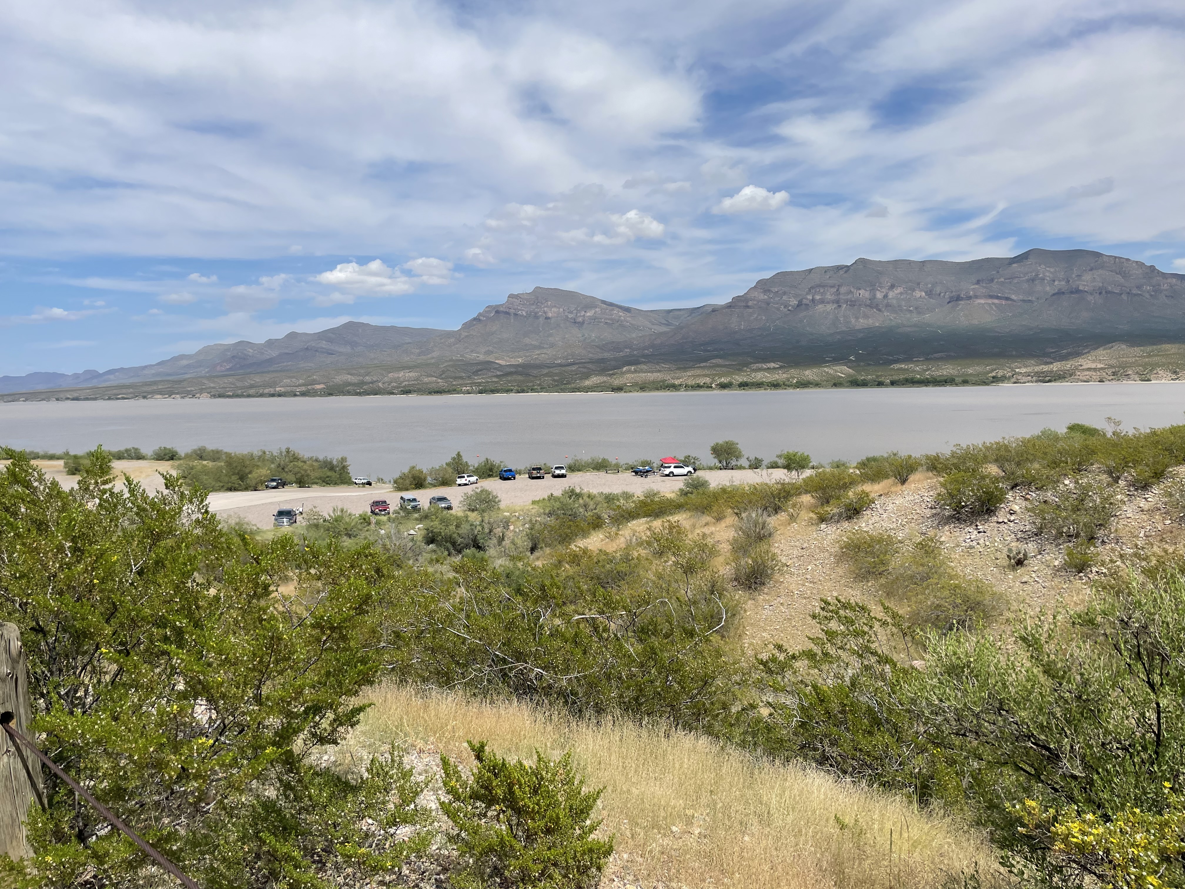
I continued with slightly better riding conditions, and gradual hills, with very gentle grade, in this area, the elevation in general is about 4000-4500 ft. This ride was short Sunday ride, I camped at the state campground on Caballo Reservoir Lake. For lunch, I rode 4-miles back, and brought some food for the evening too. It was a beautiful day, and I was kind of regretting to be in camp and not riding, but the surprise of the day came after the dinner, at just about 6:30, as I along with some fellow RV-campers, was looking down the reservoir where people were boating and fishing, and some were in water swimming. On the northern horizon, we suddenly saw on the gathering of dark clouds, in next minutes we saw it rain in the distance, but before anyone could realize, winds picked up gusting at about 45-miles or so, I ran to secure my belongings, and tent, and it was mayhem for next about an hour, with rain, wind, and hail size of a Quarter.


This was the second consecutive rained out night for me. But I was still dry and unharmed albeit a little sleep deprived.
Day three:
I packed and left the camp site at sunrise. Riding about 3-miles northward from the Cabello camp, I turned on SR-152, Except for a banana, I had not eaten any substantial breakfast, and was expecting some lunch at the restaurant in Hillsboro, but to my surprise the only restaurant at this place opens only on weekends, and this was Monday – missed by a day. Even the camp ground manager was not available, the phone service did not work either, even the post office did not have a phone. But on the positive side people of this small place were very nice, the only shop and antiques shop was managed by the grandson of the owner lady, he just opened his shop and brought a watermelon, a knife, and a bottle of water for me to eat. I ate some watermelon and took one bottle of water thanked the young man and moved on, to the next challenge. The climbs had started, slopes were rising to 7% and 8% and also 9% rising to the highest peak (pass) at the Emory pass which is at 8,228 ft. The Watermelon did its job. I reached San Larenzo, no food or water, and moved on to Mimbers about 6.6-miles on the Gilla Cliff alternate, there is a gas-cum- grocery store-cum restaurant at this place but not dependable, the restaurant closes at 2 P.M. I reached there at 2:18 and it was cleaned out, and the store has nothing edible on the shelf. Not even water was available when I stopped by, I did buy a Coke bottle because it was cold.
I camped at the RV camp, that had good bathrooms, showers, some water and ice could be bought from them, but nothing to eat. I depended on my tinned Frijole (beans) and wheat-tortilla. So far so good, and then the dreaded evening arrived, once again with high winds, and rain. It rained all night with winds hauling above 45-50 miles gust. Now I had three consecutive sleepless nights.


Day four:
Next day it was very hard to ride, and it was all climbing hills. Lack of sleep, and relatively low food intake for past two days was taking its toll. With great struggle, I continued on SR-152 going west, stopping wherever there was any opportunity. I stopped to see the open pit Santa Rita (copper) mines, and just made to Siver City.
Day five and six:
I stayed at Murry Hotel in the city, the Murry hotel has good facility for bikers, they have a locked room to safely store the bikes, and cycling goods that may not be needed in the room. They have free breakfast too. I decided to rest one extra day. This the place I met three cyclist who were doing the Continental Divide going South. I got my bike cleaned, and inspected, and I ate pizza at the Forest’s Pizza, that was very good. Silver City has number of hotels, motels, and camping sites, number of bicycle shops, and food and water replenishing place, with grocery shops like Robertson, Walmart and several others. A very good place to stay and recoup if that fits in the schedule.


Day Seven:
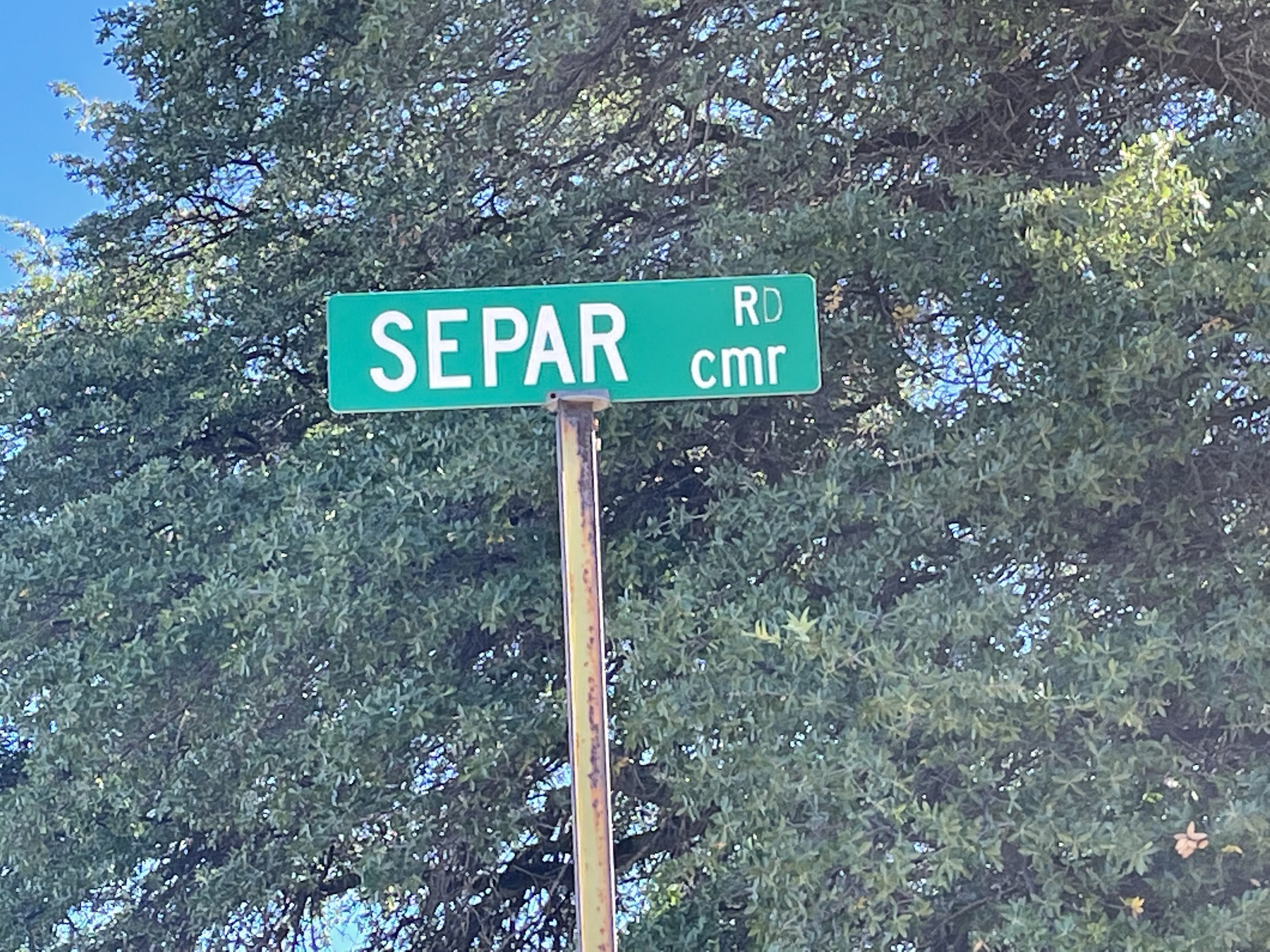
Riding south, on SR-90 a pass through Separ trail to my left, that dirt-trail is part of the Continental Divide. Riding south after the climbs, the downward slope begins that opens of a vast open desert with Saguaro, Staghorn, and occasional Devils Fingers spread for miles on both side of the road.


Day eight:
Early morning next day, I start from Lordsburg on interstate I-10, my food source was the Love’s Travel Shop (a gas station, with food and shower facility). There is a Day’s Inn Motel too close by at walking distance.
I reached Duncan, this single street small town had its Rodeo celebration on the day. The small town was alive with excitement, people, children, and animals were all dressed up for the occasion. Parade was getting ready to assemble. I accidently met these Falg-Girls riding to the Rodeo ground. The picture shows these three crisply dressed Flag-girls atop their horses. The leading them was the in charge of the rodeo Flag-Girls, most likely mother of one of these girls. If I understand correctly, these Cow-girls are also called escaramuzas in parts of Mexico.

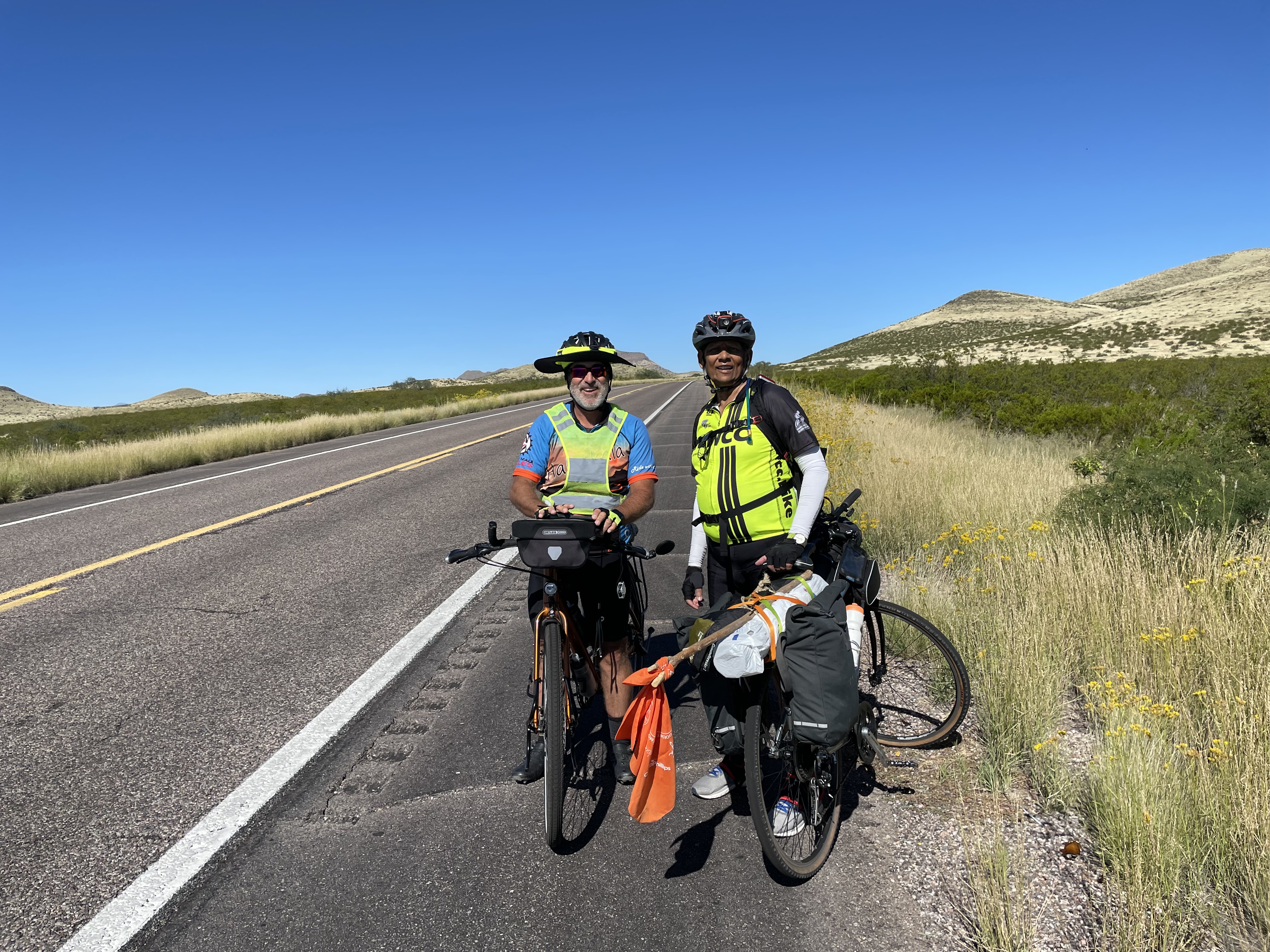
I met this rider going East to Florida. He was supported by his sister who was riding for some distance and his Brother-in-law in SUV with tools and other supports.
Moving further from Duncan I met a cyclist from California, riding East to Florida, he was following the Adventure cyclist (https://www.adventurecycling.org/routes-and-maps) Southern Tier route, His Siter was riding ahead of him, it appears for some distance and his brother-in-law was following or leading them in his car. They were nice people, in fact while talking with them, I was also trying to secure my camara tripod on my front bag, and he just pulled out tool-box from the car and secured it with a zip-tie.
This young man from Germany was going East to New York.
He was excited about the desert he had just crossed coming from LA California.
Stayed at Day’s Inn and laundered my clothes.
Day Nine: Rocky Canyon, wind vortex, and beautiful views.
Due to the wildfire somewhere enroute to Tonto basin area on SR 188, I was diverted on SR-60, going through some amazing hill roads climbing about 2,650-ft and descending about 4,500-ft. I had and unique experience on this section as was descending through the rocky canyon, I went through Old Queen Creek Tunnel, which is not very long, but narrow and has poor light, due to speed just few yards in, my bike felt a jolt and I was caught in a wind vortex, I could manage to pull on the side and slow down, that stabilized my bike and rode carefully out of the tunnel. And turned right on the Magma Avenue, Happy Camp Rd., SR-357, El Campo Viejo, somewhere there I was on SR 77 too, and through Gold Canyon back on SR-60 to Apache Junction.
There are videos of this section posted on my YouTube Channel, Ramesh Singh Adventure Cycling.
Day Ten:
At little pre-dawn, I started for Phoenix via Tempe
The day was sunny and clear and good for cycling. In general Phoenix area is very nice, and has lot of dedicated cycling routes, its Canal Trail system is good too. The initial portions of the trail, is beautiful and clean to ride, but once the trail crosses the canal under SR-17 bridge above, the trail itself is fine, but it is not good for riding, it is fraught with hazards, that includes several stoned drug addicts loitering around, some even laying prostrate across the trail itself, drug paraphernalia needles, blades, etc. scattered all over the trail, it is very scary as well as sad situation.

Colorado
There are videos of this section posted on my YouTube Channel, Ramesh Singh Adventure Cycling.
Day Eleven:
In the morning, when I started the city lights were still on, I continued on city roads. Morning sum was rising, an promising to be a clear and bright sunny day, good for cycling. The roads are good, with cycling lanes and good for safe riding condition. Roads were busy, with early morning work-traffic, but with number of wide lanes including one dedicated right lane for cyclists, riding was pleasure. I cut across, and took Bell Rd. going west which would to connect me with SR-60 going to Wickenburg.
The ride on SR-60 was, uneventful for some time, the bright sun was playing hide and seek under gathering dark clouds, then suddenly in the middle of the open desert, someone just turned the hose on and a heavy down pour started. Caught in the rain once again, there was no place to stop by so, I continued several drivers tried to indicate that they can give me lift, if I wanted. I thanked and I continued, through Wittman and Morristown, it slowed down a bit, but did not let up till Wickenburg.
Met a young man from India, he was managing local unit of Days In motel. I stayed at this place.
There are videos of this section posted on my YouTube Channel, Ramesh Singh Adventure Cycling.
Day Twelve:
Early morning start, continued on SR-60 west. This about 80 miles of ride is through desert, and some climbs too, as I was riding west, I saw clouds gathering to about 1 O’clock, and it appeared that it will meet me soon on the road, but it did not.
As I reached the Gateway Ranch RV park, and turned off the main road on Avenue 42, I saw that few yards down from the entrance the road closed sign was posted. When I checked in the Ranch and RV park manger was ready on her quad to leave she was in hurry as part of her Ranch was flooded – that clouds and rain I saw while riding few hours earlier was in fact deluging her ranch. Overnight I stayed at this place. I had time to ride 4 miles up the road to visit the local grocery shop, I could not get anything to add value to my breakfast for the morning. I had my Frijoles and tortilla for dinner.
The luxury I enjoyed at this place was that a hot shower, I could warm my food on the stove top, and sit on a sofa to plan my next day.
There are videos of this section posted on my YouTube Channel, Ramesh Singh Adventure Cycling.
Day Thirteen:
Early morning start. This was a 43-mile ride on intestate I-10, was most challenging, and taxing too. I had to fix two flats on the side of the busy I-10 traffic. Thees flats I got that riding on the shoulders of the road, that is permitted from Brenda till I exited the highway on the Hobson road that is parallel to I-10 to reach Blyth.
I realized that somewhere, I lost my water bottles (possibly left it on the side of the road) somewhere during these flat fixing. I needed them so much for next few days of the very challenging ride, so I bought two Yeti insulated bottles from ACE hardware shop, they are heavy, but that is only option I had, and it worked well for the challenges I had next day.

Algodones Dunes
See vedio on YouTube Ramesh Singh Adventure Cycling
There are videos of this section posted on my YouTube Channel, Ramesh Singh Adventure Cycling.
Day fourteen:
Started very early in the morning, I continued in SR-78, crossed I-10 under-pass, through Palo Verde where a grocery shop and gas station is the only sign of habitation.

Sunrise as I left from Blyth.
This is the most challenging day of ride a 103- mile ride through desert, with possibly only one place to find some water and food, in Glamis about 70/75-miles from Palo Verde, and in the middle of the desert. The area is deprived of any shade, occasional crossing of agricultural canals, and sand dunes.
Before I reached Brawley in that oppressive heat, I was running short of water, although I had filled my all hydration packs, I was empty. At the start I had full 7-liters of water on me, of which about 3-liters were in those Yeti thermos bottles, I bought in Blyth. I had replenished it in Glamis with more water and some ice.
The reason for that heat and feeling of being sapped out was that this place is below sea level aware of this fact, I checked my iPhone and got readings of 192 and 188 feet below sea level.
Earlier in the day, I was planning to swing by Salton Lake about 30 miles to the north of Brawley and spend a day riding there, but now not in my mind, I was so done. I missed that opportunity, and I regret it now. After a brief rest and some drink in Brawley, I rode south and camped in El Centro. I stayed here one extra day, and recouped with food and water for my next challenging ride ahead. I also bought extra tubes since I was left with no reliable tubes left with me since I had two flats two days back while riding on I-10.
I reviewed my riding plan and, decided to change my route, I decided to ignore the SR-98 that is south of I-8, for two very good reasons, (1) I had travelled on that section of the road in my 2020 ride to San Diego a blog for that is already posted. (2) I wanted to explore new route, and the suggestion of the local Bike shop owner matched my desire, decided to take the route that goes north of I-8.

There are videos of this section posted on my YouTube Channel, Ramesh Singh Adventure Cycling.
Day fifteen:
Another challenging day, I took W Evans Hewes highway, that is North of I-8.
I headed from El Centro to Coyote Wells. As stated above, I did not use the SR-98 that is to the south of I-8, instead chose to ride on W. Evan Hewes Highway north of I-8. This was more challenging for three reasons. (1) The Yuha desert was as hot as it would have been in the south, (2) the entire road if one dares to call it a road, from El Centro was worst that I have ever rode my bicycle on, as far, you keep hoping that it may get better, but it just gets worst with every paddle forward. (3) About 8-miles from El Centro as one tuns westward (Left) at Seely, there is gas-station and a busy grocery shop, for food and water. But is location as far as the entire riding distance is concerned little too early in the route. Thereafter, for next about 30-miles, there is no place in entire section to find food or water, or place to find shade from the sun and dry heat.


The above two pictures are of Yuha Desert and the road condition.
There is a US naval training base in Seely just about 3 miles north of Seely.
It seems this grocery shop is frequented by airmen from the base. I met a young US navy pilot, a Lieutenant, and his Sgt. friend, I asked the pilot what was he flying?
He responded the “Yellow Thing, Sir!
Meaning, he was in training.
He sounded kind of disappointed that he was flying “that Yellow thing”.
I told him to train well, adding “more you sweat in peace, less you bleed in war”.
He acknowledged, his eyes brightened, and asked me, “and what are you flying sir?” I pointed to my bike and said – “that”.
They both looked confused, then I introduced myself that I am a retired Indian Airforce officer, and currently I am riding cross-country to San Deigo, CA.
They both smiled, and gave me a crisp salute,
I thanked them both for their service, and resumed my journey ahead.
This brief encounter was what makes riding a pleasure, and memorable experience.
The Plaster City on the map, don’t be fooled there is nothing there that can give any hope of support to a cyclist. The place has a Gypsum processing plant straddled on both side of the road. They produce Drywall, and other insulating products, but nothing else, no water you may not even see a person. On the East side, you would however cross the only commercially active Narrow-gauge rail line in the US, that brings mined gypsum from the nearby mines to the plant.
The road is broken at places and I had to drag my bike through shin, and some places to knee deep sand resulting in maximum stress to me and my bike, just about 3-miles short of my camping destination, due to all that stress the bike chain broke. I had strongly depended on my new chain that I had put in in Silver City on Day-6 above; hence I had not carried any spare, or any tools, extra link etc. to fix the broken chain – lesson learned.
Next 3-miles to the camp site in Coyote Wells, it was a long slog in burning sun above, and hot-sand and pavement of what is called as road under my feet, it was like being in an Pizza oven, through that I was dragging myself, the bike, and the broken chain.
Man’s best friend comes to my support
Luckily to my relief, or change of situation, half a mile from the camp, I was met by a large dog, a German Shepard mix, in this heat and in the burning sand he was out I do not know why, but he was very happy to meet me or as it appeared he was also happy at my plight, I would never know. He just walked up to me, and started walking by my side, gave me company till I was at the entrance of the camp. As if he know my destination, and then he turned back. I had one Cheese stick left in my saddle bag, I called it back, and gave him the cheese-stick, very gently he took from my hand, and walked back in the direction we had met earlier, holding the cheese stick between his teeth.
Lady luck was still with me, at the camp site I met an Adventure Cyclist tour group these cyclists were camping at the same location, they had a van with them that carried their supplies and tools, they were wry friendly group of people, they fixed my chain. But now, I was left with a smaller chain, that limited the traverse of the derailer, thus limiting the selection of gear choice for next section of riding. This slowed my ride a bit but to my good fortune, the hills in this section look very intimidating, but except for some spots where the gradient might have been steeper, most of the climb gentle, slope was about 2% to 4% at most. The climb with the limited gear travers to granny sprockets worked to my advantage, and last few miles were downward slope.
All the way, my fear was, what if the chain broke again, and then what? I rode with that worry till I got to the bike shop, in Alpine CA, where I had chain replaced. The downhill slope had started little after Alpine valley, and from Alpine that downhill ride continued, it was all the way downhill, and relatively comfortable ride.
Note; that the town of Alpine is north of Barrett Lake area that I toured in 2020 trip, as described in my earlier blog.
Day sixteen: Lake Jennings
Started after sunrise. This was a very short distance ride, just to adjust my time of arrival to San Deigo, and some rest. From the camp site on to Willows Road, and crossing under Kumeyaay highway (I-8) over pass to Alpine Boulevard continued west.
On the way stopped for breakfast. Except for few steep but short rise the ride was relatively easy.
Arrived at Lake Jennigs campground, and pitched camp, did laundry, did some cleaning of my bags and bike, took shower and food.

Lake Jennigs Camp site

Sunset at Lake Jennigs
There are videos of this section posted on my YouTube Channel, Ramesh Singh Adventure Cycling.
Day eighteen:
This was little over 30-mile ride to Ocean Beach San Deigo. I started looking for the bike trail on the map, but from Santee I was already lost finding the “trail”. I met a local group of riders, and they suggested I take Highway 52 all the way to San Deigo. I did that, for some distance it was scary, as there were nearly no shoulders to ride on. But soon I saw that there was a parallel bike trail, and I found an opening to get on that trail, there after the ride was much better, though all the way I was dodging debris and tier-blowout, from puncturing through my tires, till I exited to internal city roads. They were mostly going downhill. The turn to San Deigo River trail that leads to the Ocean beach is easy to find.
On the way I saw, the posted gas prices exceeding $7/gallon, and wondered why it is when gas prices at my place were hovering around $3/gallon. I also saw occasional streets where homelessness was in full display. California is a beautiful place, but it has been made unlivable, due to heavy cost of things, and corporate greed.
I reached Ocean beach, and straight went to the waters, and dipped my bike wheels to cool in Pacific. After that I headed to Bernie’s Bike Shop at 1911 Cable Street to meet Roger Lovett. It appears that everybody who is from San Deigo and ever rode a bicycle knows Roger, including few girls I met on the beach. Roger agreed to take the bike in and immediately started to pack my bike. I realized that I was starving and wanted to eat something, and there are lots of places to eat nearby, when I returned back to shop, by than Roger had packed the bike and was ready to close the box, Thank you Roger! I stuffed some more items in the box that I could not, or did not want to carry on the flight back home, and then the Box was finally closed, shipping level was created. It was shipped next day. I shipped the bike trough Bike Flights® (https://www.bikeflights.com) which was easy and convenient, hassle free from single handed transporting the 57x28x8 inch box that is over 55 lbs. in weight to the airport, and then again from the airport to home. My bike arrived in within a week after my arrival home.


Ocean Beach San Deigo
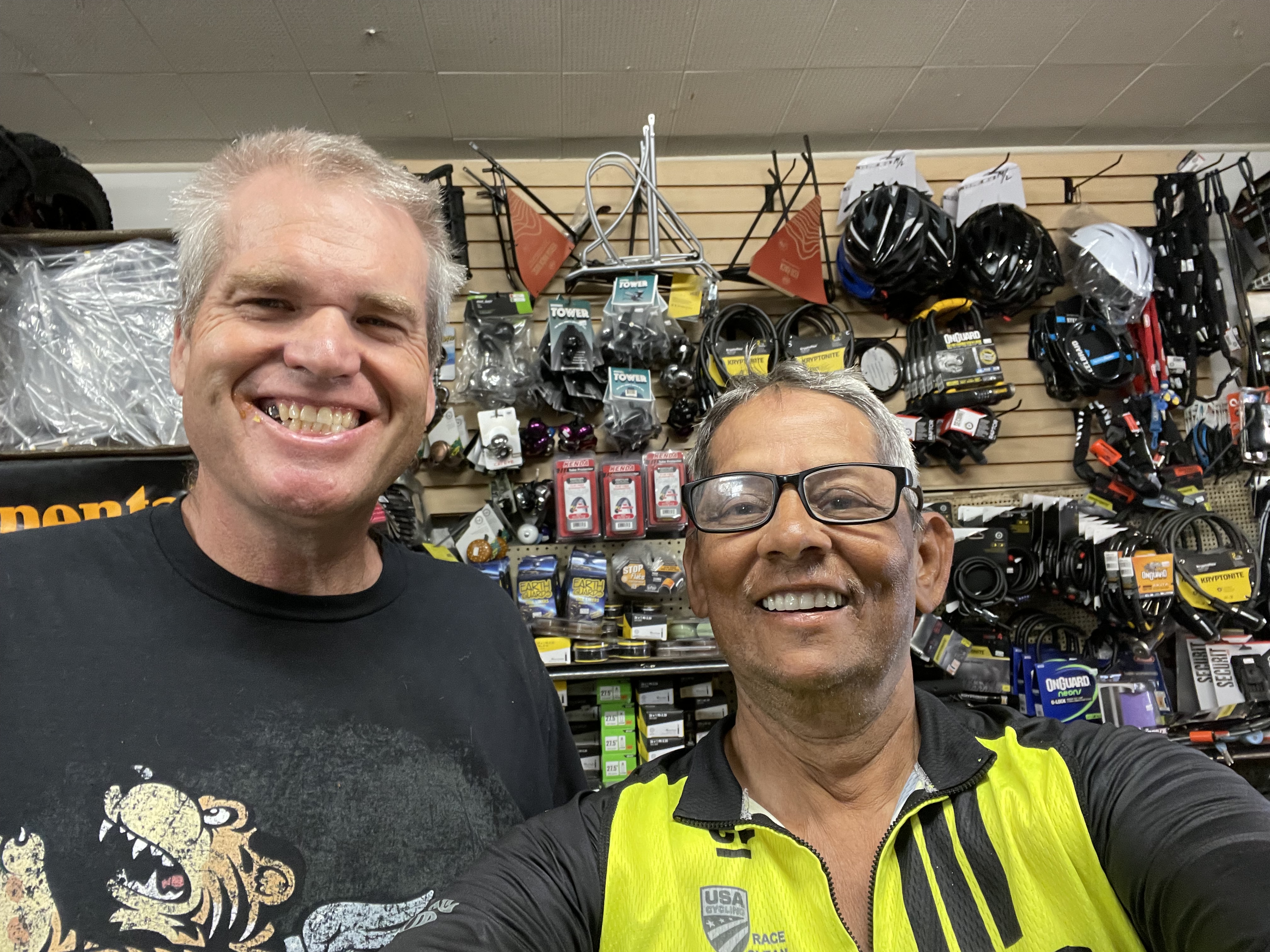
Roger Lovett and myself at Bernie’s Bicycle Shop on 1911 Cable Street San Deigo CA (Phone:619.224.7084)
The bike is packed, below.

The Bike type, and packings
I rode my trusted TREK FX series bike, aluminum frame, and Shimano gear system (https://www.trekbikes.com/us/en_US/). The only modification I did was to put a 45 mm tire, and for that I had to modify a bit but not much.
I ran standard tire and tube system, carried two extra sets of tubes.
The bike packing was simple, I placed few things that I did not need to remove from bike were distributed on the handle bar and back panniers. The tent and the sleeping pad were rolled up and tied on top of panniers. The front handle also supported my cameras and few navigation electronics, they were all removed from the bike if I had to leave my bike out of mu sight, such for shopping. In bike packing the most important thing is ensure that the load is well balanced. By balance I imply in both sideways, and front and back, the load is stable when riding, and it does not rock and make it hard to pull. Heavy load in the back is difficult to push in steep climbs either by paddling or if one has to walk the bike uphill.
It is strongly recommended that after packing the rider rides the bike number of times to ensure the weight is balanced and comfortable. If required adjust number of times till fully satisfied, little effort pre ride will save lots of problem during the ride itself.
The picture below shows my bike and how I have packed it.

